
On Sept. 4, 2019, a loose chain of tropical cyclones lined up across the Western Hemisphere. At the time of this image (1:10 p.m. EDT) Hurricane Juliette in the East Pacific and Hurricane Dorian in the Atlantic were both category 2 storms.
Meanwhile, Tropical Storm Fernand packed sustained winds of 45 mph and had just recently made landfall over northeastern Mexico. Gabrielle strengthened into a tropical storm on September 4 over the eastern Atlantic, and had sustained winds of 50 mph around the time of this image.
Data for the simulated natural-color image were acquired with the Advanced Baseline Imager on the Geostationary Operational Environmental Satellite (GOES) 16. GOES-16 is operated by NOAA; NASA helps develop and launch the GOES series of satellites.
Image credit: NASA Earth Observatory/Joshua Stevens; NOAA National Environmental Satellite, Data, and Information Service. Caption: Kathryn Hansen.
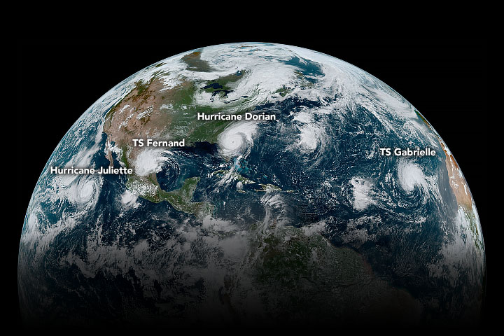
Labeled image of the chain of tropical cyclones lined up across the Western Hemisphere on Sept. 4, 2019.
Credits: NASA Earth Observatory/Joshua Stevens; NOAA National Environmental Satellite, Data, and Information Service.
2019年9月4日,一串松散的热带气旋横贯西半球。在这张照片拍摄的时候(美国东部时间下午1点10分),东太平洋的朱丽叶飓风和大西洋的多里安飓风都是2级风暴。
与此同时,热带风暴弗尔南多持续风速45英里每小时,最近刚刚在墨西哥东北部登陆。加布里埃尔于9月4日在东大西洋上空增强为热带风暴,在这张照片拍摄期间,风速一直保持在每小时50英里。
利用地球静止运行环境卫星(GOES) 16上的先进基线成像仪获得了模拟自然彩色图像的数据。GOES-16由NOAA运营;美国宇航局帮助开发和发射GOES系列卫星。
图片来源:NASA Earth Observatory/Joshua Stevens; NOAA National Environmental Satellite, Data, and Information Service. 说明文字:Kathryn Hansen.
2019年9月4日,热带气旋链在西半球排列成行。
影像来源:NASA Earth Observatory/Joshua Stevens; NOAA National Environmental Satellite, Data, and Information Service.

