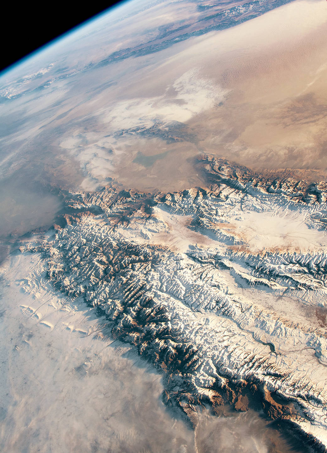
2018年12月,国际空间站一名宇航员在中亚天山东部和塔克拉玛干沙漠拍摄了这张高度倾斜的雪景照片。天山是世界上最长的连续山脉之一,绵延1500英里(2500公里),位于中国西北部、哈萨克斯坦和吉尔吉斯斯坦。
天山,有时被称为中亚的水塔,为该地区提供了必要的淡水。由于塔克拉玛干沙漠是一个三面环山的低洼盆地,雨影效应使该地区一年中的大部分时间都非常干燥。
天山拥有亚洲许多主要冰川。在春季和夏季,冰雪的融化补充了当地的河流,并将侵蚀的沉积物输送到山谷。冲积扇沉积的沉积物垂直于周围的山脉,这些山脉被风重新加工、侵蚀并输送到更远的地方。
塔克拉玛干地区以沙丘为主,具有易移动的沉积物。这个地区的风能产生很大的沙尘暴。在这幅图中,雪从天山的山峰和山谷延伸到塔克拉玛干沙漠的底层。NASA的Terra和Aqua卫星上搭载的中分辨率成像光谱仪(MODIS)仪器也能在同一天提供该地区积雪的更多定量图像。沙漠上覆盖着厚厚的积雪,透过尘埃云,可以看到博斯腾湖。
这张照片是2018年12月5日拍摄的,使用尼康D5数码相机拍摄,镜头为65毫米,由国际空间站宇航员地球观测设施和约翰逊航天中心地球科学与遥感单元提供。这张照片是由探险队57名成员拍摄的。图像经过裁剪和增强以提高对比度,并删除了镜头伪影。作为国际空间站国家实验室的一部分,国际空间站项目支持该实验室帮助宇航员拍摄对科学家和公众最有价值的地球照片,并将这些照片免费发布在互联网上。
In December 2018, an astronaut on the International Space Station took this highly oblique photograph of snow on the eastern Tien Shan and Taklimakan Desert in Central Asia. The Tien Shan (or Tian Shan) is one of the longest continuous mountain ranges in the world, stretching across 1,500 miles (2,500 kilometers) in northwest China, Kazakhstan, and Kyrgyzstan.
The Tien Shan Mountains, sometimes called Central Asia’s Water Tower, provide essential fresh water to the area. Since the Taklimakan Desert is a low-lying basin enclosed by mountain ranges on three sides, a rain shadow keeps the region extremely dry for most of the year.
The Tien Shan hold many of Asia’s major glaciers. In the spring and summer, the melting of ice and snow replenishes local rivers and transports eroded sediment to valleys. Alluvial fans deposit sediment perpendicular to the surrounding mountain ranges that get reworked, eroded, and transported farther by wind.
The Taklimakan is dominated by sand dunes with easily mobilized sediments. Winds in this region are capable of producing large dust storms. In this image, snow extends from peaks and valleys of the Tien Shan to the lower desert floor of the Taklimakan Desert. The Moderate Resolution Imaging Spectroradiometer (MODIS) instruments on NASA’s Terra and Aqua satellites also offer a more quantitative view of snow cover in the region on the same day. Blankets of snow are visible on the desert through dusty haze, which obscures Bosten Lake.
Image Credit: NASA
Caption: Andrea Meado, Jacobs Technology
Astronaut photograph ISS057-E-111453 was acquired on December 5, 2018, with a Nikon D5 digital camera using a 65 millimeter lens and is provided by the ISS Crew Earth Observations Facility and the Earth Science and Remote Sensing Unit, Johnson Space Center. The image was taken by a member of the Expedition 57 crew. The image has been cropped and enhanced to improve contrast, and lens artifacts have been removed. The International Space Station Program supports the laboratory as part of the ISS National Lab to help astronauts take pictures of Earth that will be of the greatest value to scientists and the public, and to make those images freely available on the Internet. Additional images taken by astronauts and cosmonauts can be viewed at the NASA/JSC Gateway to Astronaut Photography of Earth.

