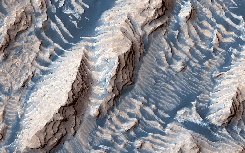
This image taken by the Mars Reconnaissance Orbiter spacecraft shows sedimentary rock and sand within Danielson Crater, an impact crater about 42 miles or 67 kilometers in diameter, located in the southwest Arabia Terra region of Mars.
The rock was formed millions or billions of years ago when loose sediments settled into the crater, one layer at a time, and were later cemented in place. Cyclical variations in the sediment properties made some layers more resistant to erosion than others. After eons, these tougher layers protrude outward like stair steps. Across these steps, the winds have scattered sand (typically appearing darker and less red, i.e. “bluer” in contrast-enhanced color), giving rise to the zebra stripe-like patterns visible here.
This image completes a stereo pair over this location, which will allow measurement of the thicknesses of these sedimentary layers. The layer thicknesses and how they vary through time can provide some insight into the processes, possibly linked to ancient climate, that deposited the layers so long ago.
The map is projected here at a scale of 50 centimeters (19.7 inches) per pixel. (The original image scale is 57.2 centimeters [22.5 inches] per pixel [with 2 x 2 binning]; objects on the order of 172 centimeters [67.7 inches] across are resolved.) North is up.
Image Credit: NASA/JPL-Caltech/University of Arizona
这张由火星勘测轨道飞行器拍摄的照片显示了达尼埃尔森陨石坑内的沉积岩和沙子。达尼埃尔森陨石坑位于火星的阿拉伯半岛西南部,直径约为42英里或67公里。
这块岩石形成于数百万年或数十亿年前,当时松散的沉积物一层一层地沉积进火山口,后来又被粘合在一起。沉积物性质的周期性变化使某些岩层比其他层更耐侵蚀。经过亿万年,这些更坚硬的岩层像楼梯台阶一样向外突出。在这些台阶上,风吹散了沙子(通常呈现较暗和较浅的红色,即在对比增强的颜色中更蓝),导致斑马条纹状的图案可见这里。
这幅图像在这个位置上完成了一对立体图像,这将允许测量这些沉积层的厚度。这一岩层的厚度以及它们如何随着时间的推移而变化,可以让我们对沉积这些层的过程有一些了解,这些过程可能与很久以前形成这些层的远古气候有关。
地图在这里以每像素50厘米(19.7英寸)的比例投影。(原始图像比例尺为57.2厘米[22.5英寸]/像素[2×2边];分辨率为172厘米(67.7英寸)的物体就可以分辨出来。)北面向上。
图片来源:NASA/JPL-Caltech/University of Arizona

