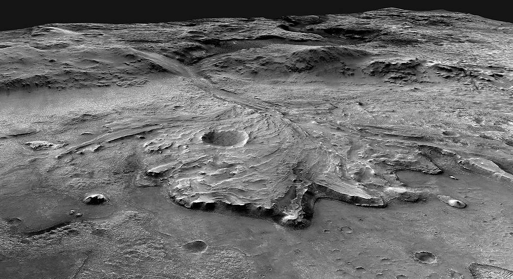
This image depicts a possible area through which the Perseverance Mars rover could traverse across Jezero Crater as it investigates several ancient environments that may have once been habitable. The route begins at the cliffs defining the base of a delta produced by a river as it flowed into a lake that once filled the crater. The path then traverses up and across the delta toward possible ancient shoreline deposits, and then climbs the 2,000-foot-high (610-meter-high) crater rim to explore the surrounding plains. About half of this traverse could be completed in Perseverance’s prime mission (one Mars year, or two Earth years). For reference, the prominent crater near the center of the image is about 0.6 miles (1 kilometer) across.
Scientists believe the area was once flooded with water and was home to an ancient river delta. The process of landing site selection involved a combination of mission team members and scientists from around the world, who carefully examined more than 60 candidate locations on the Red Planet. After the exhaustive five-year study of potential sites, each with its own unique characteristics and appeal, Jezero rose to the top.
Jezero Crater tells a story of the on-again, off-again nature of the wet past of Mars.
Image Credit: NASA/JPL-Caltech/USGS
这张图片描绘了毅力号火星车穿越耶泽罗陨石坑 的可能区域,它正在调查几处曾经适宜人类居住的古老环境。路线从峭壁开始,形成了一个三角洲的底部,这个三角洲是一条河流流入一个曾经填满火山口的湖泊时形成的。然后,这条小路向上穿过三角洲,寻找可能的古代海岸线沉积物,然后爬上2000英尺(610米)高的火山口边缘,探索周围的平原。在毅力号的主要任务(火星一年,或者地球两年)中,可以完成这段旅程的一半。作为参考,图片中心附近突出的陨石坑直径约为0.6英里(1公里)。
科学家认为,该地区曾经被洪水淹没,是一个古老的河流三角洲的家园。选择着陆点的过程包括任务小组成员和来自世界各地的科学家,他们仔细检查了火星上的60多个候选地点。经过为期五年的详尽研究,每个着陆点都有自己独特的特点和吸引力,耶泽罗陨石坑脱颖而出。
耶泽罗陨石坑讲述了火星湿润的过去时断时续的故事。
影像来源:NASA/JPL-Caltech/USGS

