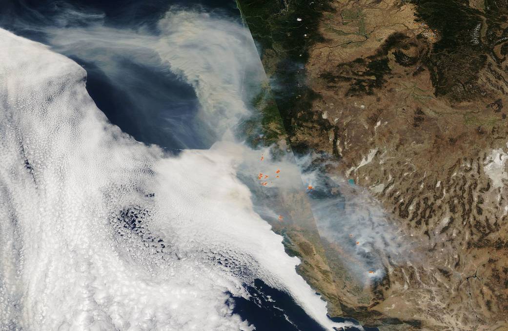
Our Aqua satellite captured this composite visible (left) and infrared (right) image on Sep. 29, 2020, which shows that fires and smoke continue to dominate the landscape of the western U.S. The visible image shows the smoke and the infrared image shows the heat from the fires (orange points). The California Department of Forestry and Fire Protection (CAL Fire) page for Sep. 30 finds many large fires still active throughout California and the Pacific Northwest. The August Complex in California continues to be the largest wildfire still active and uncontained at 949,055 acres, located in Glenn, Lake, Mendocino, Tehama, and Trinity Counties. The August Complex is the largest wildfire in California’s history having surpassed the Mendocino Complex fire which burned 459,123 acres in July 2018. In this image, the smoke which had previously crossed the country by heading east has now shifted and is heading out to the west, billowing out over the Pacific Ocean.
Further complicating fighting the fires is the weather pattern predicted by the National Interagency Fire Center (NIFC) in its daily report from Sep. 30, 2020: “A broad upper ridge building over the West will yield increasingly hot, dry, and unstable conditions for California, the Desert Southwest, and the Great Basin. Fires actively burning in Northern California will be challenged by near or record-breaking heat and very low relative humidities.” The NIFC also provides predictive maps to show areas that have above normal significant wildland fire potential.
NASA’s satellite instruments are often the first to detect wildfires burning in remote regions, and the locations of new fires are sent directly to land managers worldwide within hours of the satellite overpass. Together, NASA instruments detect actively burning fires, track the transport of smoke from fires, provide information for fire management, and map the extent of changes to ecosystems, based on the extent and severity of burn scars.
Image Credit: NASA
我们的Aqua卫星于2020年9月29日拍摄了这张可见光(左)和红外(右)合成图像,显示火焰和烟雾继续占据着美国西部的景观。可见光图像显示烟雾,红外图像显示火焰产生的热量(橙色点)。加州林业和消防部门(加州火灾)9月30日的页面发现,许多大型火灾仍然活跃在整个加州和太平洋西北部。加州8月份发生的大火仍然是最大的未被控制的火灾,面积达949,055英亩,分布在格伦、莱克、门多西诺、特哈马和三一县。8月的大火是加州历史上最大的火灾,超过了2018年7月发生的门多西诺大火,火灾面积达45.9123英亩。在这张图片中,之前向东穿越整个国家的烟雾现在已经转移并向西移动,在太平洋上空翻腾。
国家跨机构消防中心(NIFC)在2020年9月30日的每日报告中预测的天气模式进一步加剧了这场大火的复杂性:“西部一个广阔的上部山脊建筑将给加州、西南沙漠和大盆地带来越来越炎热、干燥和不稳定的条件。在加利福尼亚北部积极燃烧的大火将受到接近或创纪录的高温和非常低的相对湿度的挑战。” NIFC还提供了预测性地图,以显示超出正常的重大野火潜力的地区。
NASA的卫星仪器通常是最先探测到检测偏远地区燃烧的野火的仪器,而新火的发生地点则在卫星立交所数小时内直接发送给全球的土地管理人员。NASA的仪器可以探测到正在燃烧的火灾,追踪火灾产生的烟雾,为火灾管理提供信息,并根据烧伤疤痕的程度和严重程度绘制出生态系统变化的范围。
影像来源:NASA

