NASA的图像显示了美国各地的火灾和飓风
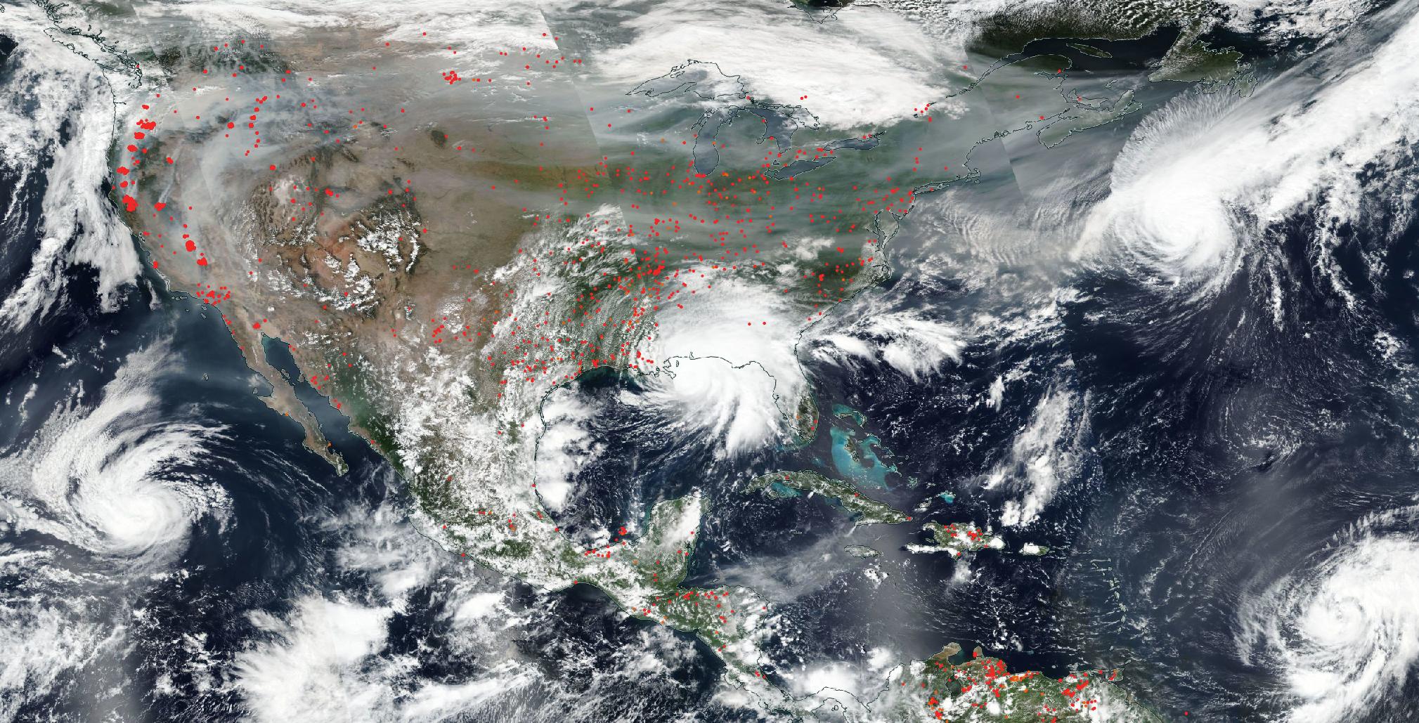
NASA’s Aqua satellite captured this true-color image of the United States on Sep. 15, 2020, showing the fires in the West, the smoke from those fires drifting over the country, several hurricanes converging from different angles, and Hurricane Sally making landfall. Red points in the west note areas that are significantly higher in temperature than the areas around it and are indicative of fires. These points are most pronounced up and down the West Coast, but dot the country from coast-to-coast as well. In addition, in this image are captured four hurricanes/tropical storms in both the East and the West. On the left hand side is Karina which is moving away from the Baja California area. Hurricane Sally, seen in the middle of the image, made landfall overnight on the Gulf Coast bringing catastrophic flooding in its wake. Hurricane Paulette sits off the East Coast near Bermuda with winds of 74 mph, although no landmasses are threatened. Hurricane Teddy, in the lower right hand corner is east of the Leeward Islands, also has sustained winds of 74 mph, and is traveling westnorthwest. Satellite images are generated every single day, in fact multiple times from multiple satellites, but it is still very unusual to capture an image of so many hazards in one image.
For more than five decades, NASA has used the vantage point of space to understand and explore our home planet, improve lives and safeguard our future. NASA brings together technology, science, and unique global Earth observations to provide societal benefits and strengthen our nation. Advancing knowledge of our home planet contributes directly to America’s leadership in space and scientific exploration.
Credit: NASA Worldview, Earth Observing System Data and Information System.
NASA公司的Aqua卫星于2020年9月15日拍摄了这张美国的真彩色照片,照片中显示了西部的大火,大火产生的浓烟在国家上空飘荡,数个从不同角度汇聚的飓风以及萨利飓风登陆。西面的红点表示气温明显高于周围地区,并指示有火情发生。这些点在西海岸上下最为明显,但也遍布全国各地。另外,在这张图片中,我们可以看到东方和西方的四个飓风/热带风暴。左侧是卡琳娜,它正离开下加利福尼亚州地区。图中所示的飓风莎莉夜间在墨西哥湾海岸登陆,带来了灾难性的洪水。飓风波莱特位于百慕大附近的东海岸,风速为每小时74英里,但是没有任何陆地受到威胁。位于右下角的飓风泰迪位于背风群岛的东部,风速也保持在每小时74英里,正在向西西北方向移动。卫星图像是每天生成的,实际上是从多个卫星生成多次的图像,但是在一张图像中捕获这么多危害的图像仍然非常不寻常。
50多年来,NASA利用太空的优势来了解和探索我们的家园,改善人们的生活,保护我们的未来。NASA将技术、科学和独特的全球地球观测结合在一起,为我们的国家带来社会效益和力量。不断增长的对我们家园星球的了解直接有助于美国在太空和科学探索方面的领导地位。
影像来源:NASA Worldview, Earth Observing System Data and Information System.