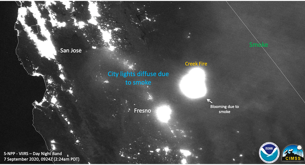
This NOAA/NASA Suomi NPP satellite image from Sept. 7, 2020, shows the night band image of the Creek Fire at night as well as the smoke from the fire causing lights at night to diffuse or “bloom.” NASA’s satellite instruments are often the first to detect wildfires burning in remote regions, and the locations of new fires are sent directly to land managers worldwide within hours of the satellite overpass. Together, NASA instruments detect actively burning fires, track the transport of smoke from fires, provide information for fire management, and map the extent of changes to ecosystems, based on the extent and severity of burn scars. NASA has a fleet of Earth-observing instruments, many of which contribute to our understanding of fire in the Earth system. Satellites in orbit around the poles provide observations of the entire planet several times per day, whereas satellites in a geostationary orbit provide coarse-resolution imagery of fires, smoke and clouds every five to 15 minutes. For more information visit: https://www.nasa.gov/mission_pages/fires/main/missions/index.html.
Image Credit: NOAA/NASA
2020年9月7日,美国国家海洋和大气管理局/美国国家航空航天局(NOAA/NASA)的Suomi NPP卫星图像显示了夜晚的溪流火情,以及夜晚的烟雾,这些烟雾导致灯光扩散或“绽放”。NASA的卫星仪器往往是最先探测到偏远地区正在燃烧的野火的仪器,而新的火灾地点在卫星立交桥几小时内就会直接发送给世界各地的土地管理人员。总之,NASA的仪器可以探测到正在燃烧的火灾,追踪火灾产生的烟雾,为火灾管理提供信息,并根据烧伤疤痕的程度和严重程度绘制出生态系统变化的范围。 NASA拥有大量的地球观测仪器,其中许多仪器有助于我们了解地球系统中的火灾。极地轨道上的卫星每天提供几次对整个星球的观测,而在地球静止轨道上运行的卫星每5到15分钟提供一次关于火灾、烟雾和云的粗分辨率图像。更多信息请访问:https://www.nasa.gov/mission_pages/fires/main/missions/index.html。
影像来源:NOAA/NASA