2022年6月8日
Ship Tracks over the Pacific Ocean
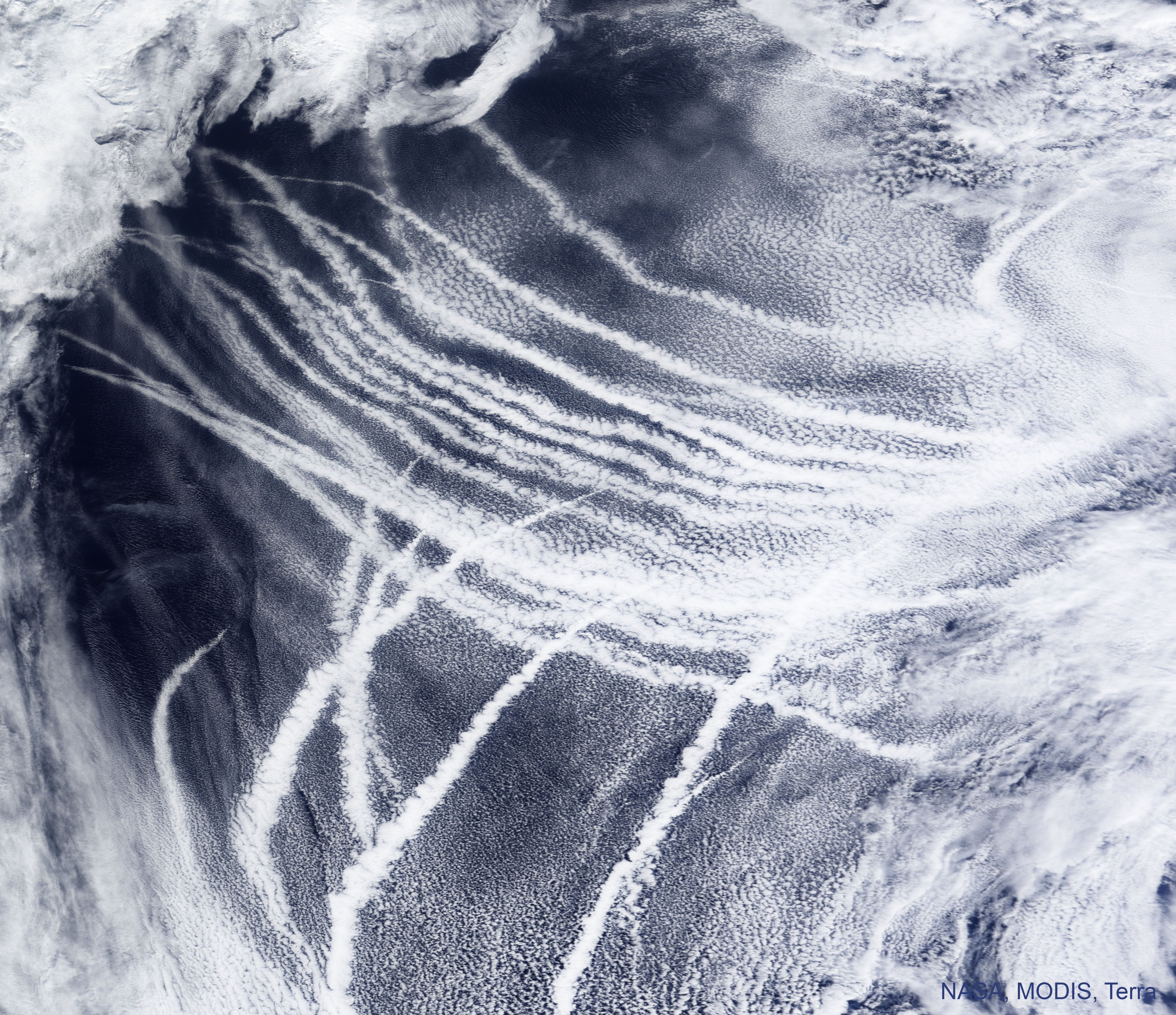
Image Credit: NASA, Terra, MODIS; Text: Raymond Shaw (MTU)
Explanation: What are those unusual streaks? Some images of planet Earth show clear bright streaks that follow the paths of ships. Known as ship tracks, these low and narrow bands are caused by the ship’s engine exhaust. Water vapor condenses around small bits of exhaust known as aerosols, which soon grow into floating water drops that efficiently reflect sunlight. Ship tracks were first discovered in 1965 in Earth images taken by NASA’s TIROS satellites. Multiple ship tracks are visible across the featured image that was captured in 2009 over the Pacific Ocean by the MODIS instrument on NASA’s Terra satellite. Inspired by ship-tracks, some scientists have suggested deploying a network of floating buoys in the worlds’ oceans that spray salt-aerosol containing sea-water into the air so that, with the help of the wind, streams of sunlight-reflecting clouds would also form. Why do this? These human-made clouds could reflect so much sunlight they might help fight global warming.
Today is: World Oceans Day
Tomorrow’s picture: open space
太平洋面的船舶轨迹
影像提供: NASA, Terra, MODIS; 文稿: Raymond Shaw (MTU)
说明: 那些不寻常的条纹是什么?地球的某些影像,会清楚记录到与船只航路重叠的清晰明亮条纹。这些低悬在海面的狭窄带纹称为船舶轨迹,其源头为船舶引擎的排气。排气中的水蒸气,会凝结在废气里的微细气溶胶周围,并很快的聚成漂浮的水滴,进而高效率的反射阳光。船舶轨迹是在1965年,首先发现于NASA TIROS卫星所拍摄的地球影像里。而在2009年,由NASA Terra卫星MODIS感测器摄于太平洋上空的这幅主题影像里,亦可见到多条船舶轨迹。受到这种船轨的启发,有科学家建议在世界各地的海洋里,布署一个能把含海水的盐气溶胶喷到空气中的浮标网络,然后在风推送下,形成不停反射阳光的条状流云。为什么要这样做?这种人造云可以反射大量的阳光,或许有助于对抗全球暖化。
今天是: 世界海洋日
明日的图片: open space