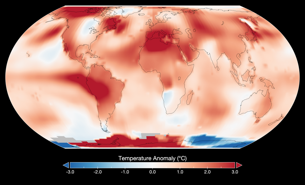
气温上升: NASA确认2024年为有记录以来最热年份
NASA科学家的分析表明,2024年地球的平均地表温度为有记录以来最热的一年。


Local students take in the sights—and data—at an Earth Information Center student engagement event, Friday, June 23, 2023, at NASA Headquarters in Washington. The Earth Information Center is a new immersive experience that combines live data sets with innovative data visualization and storytelling t

A Rocket Lab Electron rocket stands on Pad B, Launch Complex 1, in Māhia, New Zealand, just ahead of a successful launch on Friday, May 26, with NASA’s Time-Resolved Observations of Precipitation structure and storm Intensity with a Constellation of Smallsats (TROPICS) CubeSats payload. Now that the

Officials from NASA, the Indian Space Research Organisation (ISRO), and the Indian Embassy visit a clean room at NASA’s Jet Propulsion Laboratory on Feb. 3, 2023, to view the scientific instrument payload for the NASA-ISRO Synthetic Aperture Radar (NISAR) mission. The NISAR mission—a joint eff


The Moon makes a stunning backdrop for the successful launch of the third in a series of polar-orbiting weather satellites for the National Oceanic and Atmospheric Administration (NOAA) and our Low-Earth Orbit Flight Test of an Inflatable Decelerator (LOFTID) on Nov. 10 at 4:49 a.m. EST from Vandenb

Since 2015, scientists participating in NASA’s Arctic Boreal Vulnerability Experiment (ABoVE) have been studying the impacts of climate change on Earth’s far northern regions and how those changes are intertwined. As our planet warms, permafrost—layers of soil that have stayed frozen for at least tw

2022年8月22日 Earth’s Recent Climate Spiral Video Credit: NASA’s Scientific Visualization Studio Explanation: Is our Earth warming? Compared to the past 250 million years, the Earth is currently enduring a relative cold spell, possibly about four degrees Celsius below average. Over the past

一旦卫星进入轨道,SWOT任务不仅将定期监测像俄勒冈州威拉米特这样的强大河流(如图),而且还将监测直径至少330英尺(100米)的小河流。 影像来源:美国能源部 地表水和海洋地形任务将对地球上95%以上的湖泊、河流和水库进行测量。 水就是生命,但尽管水很重要,但人类对地球淡水体的看法却出奇地有限。研究人员对全球仅有的几千个湖泊进行了可靠的水位测量,而地球上一些重要的河流系统几乎没有数据。即将到来的地表水和海洋地形(SWOT)卫星将填补这一巨大空白。通过帮助人们更好地了解地球的水循环,它将有助于更好地管理水资源,并扩大对气候变化如何影响湖泊、河流和水库的知识。 由NASA和法国航天局国家空间研究