火星全图:地面观测版
2020年11月20日
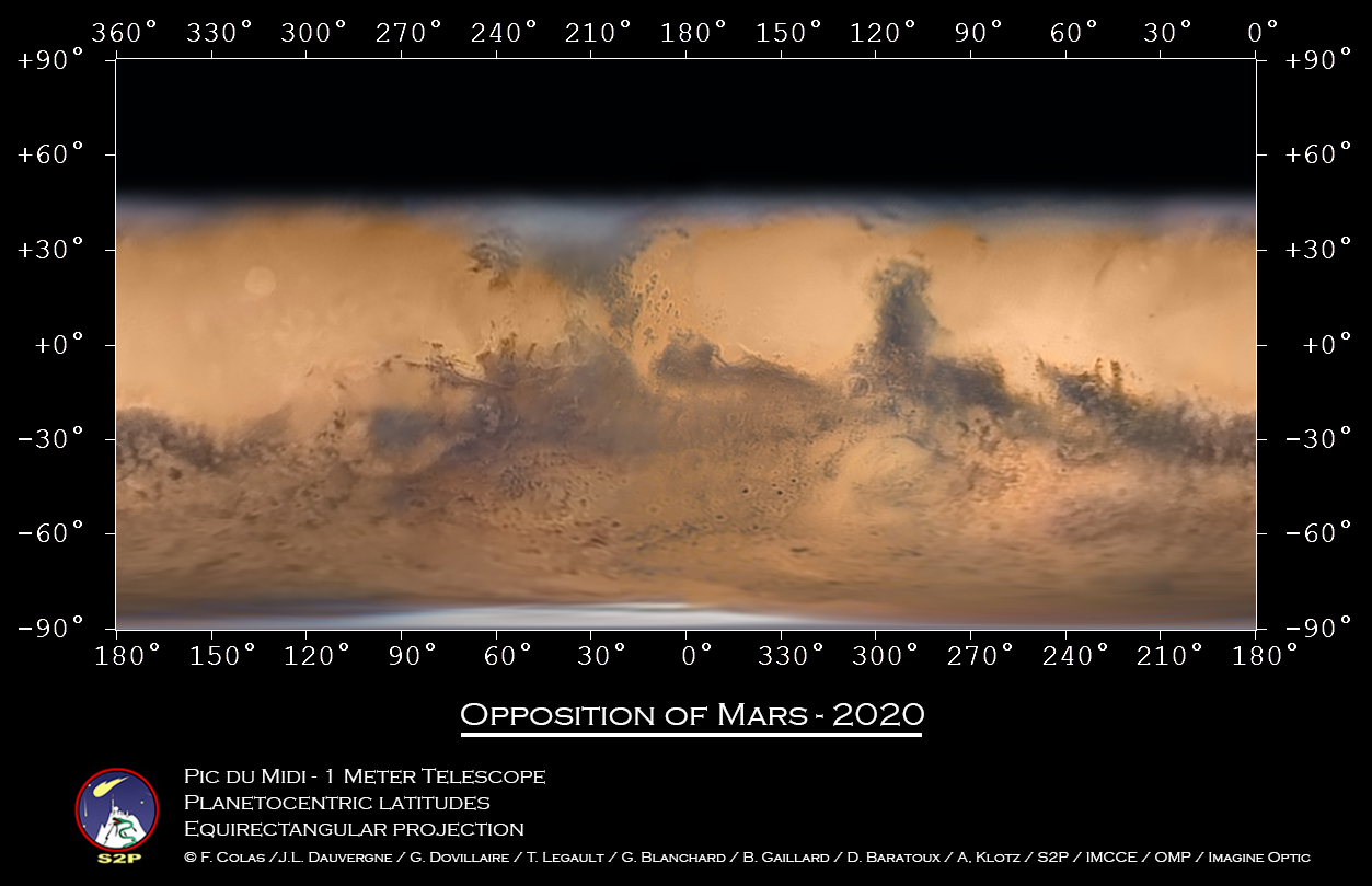
Global Map: Mars at Opposition
Image Credit & Copyright: F. Colas / J.L. Dauvergne / G. Dovillaire / T. Legault /
G. Blanchard / B. Gaillard / D. Baratoux / A, Klotz / S2P / IMCCE / OMP / Imagine Optic
Explanation: This may be the best global Mars map made with a telescope based on planet Earth. The image data were captured by a team of observers over six long nights at the Pic du Midi mountaintop observatory between October 8 and November 1, when the fourth rock from the Sun had not wandered far from its 2020 opposition and its biggest and brightest appearance in Earth’s night sky. The large telescope used, 1 meter in diameter with a 17 meter focal length, was also used in support of NASA’s Apollo lunar landing missions. After about 30 hours of processing, the data were combined to produced this remarkably sharp projected view of the martian surface extending to about 45 degrees northern latitude. The image data have also been mapped onto a rotating sphere and rotating stereo, views. Fans of Mars can easily pick out their favorite markings on the Red Planet by eyeing a labeled version of this global map of Mars.
Tomorrow’s picture: light-weekend
火星全图:地面观测版
影像提供与版权: F. Colas / J.L. Dauvergne / G. Dovillaire / T. Legault /
G. Blanchard / B. Gaillard / D. Baratoux / A, Klotz / S2P / IMCCE / OMP / Imagine Optic
说明: 此图或许是用地面望远镜数据,所能绘制的最佳火星全图。制图所使用的影像数据,是在10月8日到11月1日之间的6个晚上,由一群位在南峰天文台的观测者所记录;在当时地球夜空中,既大又亮的火星则离2020火星冲不远。用来观测的1米口径、17米焦长望远镜,以前曾参与美国航太总署的阿波罗计画,协寻合适的登月点。观测之后,数据接着经过30小时的后续处理,最后整合成这幅无比清晰、最北涵盖45度的火星表面投影图。而这批影像数据,也另外制成呈现自转的球形图和立体图。火星的粉丝们如果参照这张加注的火星全图,应可轻易找到所钟爱的火星表面标记。
明日的图片: light-weekend